Analyzing the flying site terrain and landing/takeoff areas is the foundation of safety in paragliding. A pilot must be able to "read" the environment to determine airflow patterns and identify potential hazards.
Here is the professional English translation and analysis of these critical components:
1. Mountain Terrain Analysis
The shape of the mountain directly dictates the character of the wind and thermal activity:
Slope Orientation (Aspect): The slope should ideally face into the wind. Solar orientation is also vital; south-facing slopes heat up faster, creating stronger thermals.
Slope Shape:
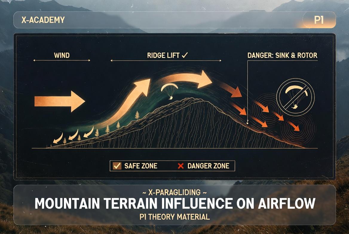
Convex: Dangerous because the wind accelerates at the crest and can create turbulence or a "venturi" effect right where you stand.
Concave: Ideal for soaring, as the wind collects in the "bowl," creating a consistent and predictable upward lift.
The Venturi Effect: In valleys between two mountains or narrow passes, wind speed increases significantly. Pilots must avoid these "pinch points" during strong winds.
2. Takeoff (Launch) Site Analysis
A good launch is 50% of a successful flight. A launch site must meet the following criteria:
Gradient (Incline): A moderate slope is optimal. On a slope that is too steep, it is difficult to control the wing; on a flat surface, it is harder to gain flight speed.
Surface Conditions: The area must be clear of large rocks, bushes, and trees to prevent lines from snagging or tangling.
Trigger Points: Locations where thermals break away from the ground and rise. Experienced pilots look for these points near the launch to gain immediate altitude.
Abort Zone: A clear space where a pilot can safely stop the launch attempt if the inflation or wing check goes wrong.
3. Landing Zone (LZ) Analysis
When landing, the margin for error is minimal. We evaluate a landing field using the L-O-S-S principle:
L (Layout): The overall size, shape, and approach paths of the field.
O (Obstacles): Identifying power lines, trees, buildings, or fences that could snag the wing or create turbulence.
S (Surface): The condition of the ground (e.g., tall grass, wet soil, rocks, or plowed earth).
S (Slope): Identifying any incline. Landing uphill is always safer and more effective than landing downhill.
Rotor Zones: If there are trees or buildings upwind of the LZ, they create a rotor (turbulent air) behind them. The landing spot should be at least 7–10 times the height of the obstacle away from it.
4. Wind Indicators
When analyzing a site, pilots observe both man-made and natural indicators:
Windsock: Provides the most accurate real-time direction and velocity.
Natural Cues: Rustling leaves, the movement of tall grass, smoke direction, or "cat's paws" (dark ripples) on the surface of a nearby lake.
Key Technical Terms:
Laminar Flow: Smooth, non-turbulent airflow.
Rotor: A turbulent, tumbling air mass found on the downwind side of an obstacle.
Wind Gradient: The variation in wind speed at different altitudes, usually slower near the ground due to friction.
Thermic: A column of rising warm air.