Introduction: Weather and Paragliding Safety
Paragliding is directly tied to weather changes. Our only engine is the air, sun, gravity, and weather. For a beginner, or P1 (student) pilot, learning meteorology thoroughly isn't just about memorizing rules, it's a vital survival skill. Paragliding is not just jumping with a "flying parachute"; it's flying controlled by air masses and forces.
1. Micrometeorology and Air Mass Movement
Why does the wind blow? The main causes are the sun and temperature differences. The Earth's surface (mountains, valleys, forests, lakes) heats up unevenly from solar radiation.
- Albedo and Heating: Dark surfaces (e.g., plowed fields, rocks, asphalt) absorb solar heat better and quickly heat the air above them. Light surfaces (snow, lakes, forests) reflect heat or heat up slowly. Warm air becomes lighter and rises, with cold air moving in to take its place - this movement creates wind and thermals.
- Pressure: Air masses always move from high pressure to low pressure. Imagine an inflated balloon: when you release it, the air (high pressure) flows out (to low pressure). The same happens in nature - wind is the result of pressure differences.
2. Atmospheric Stability: "Stable or Unstable?"
Air temperature changes as altitude increases (Lapse Rate).
- Stable Atmosphere: If temperature drops slowly with altitude (or there's a warm layer - an inversion), the air is stable. This means air masses don't want to rise. Flying is calm and "smooth" during this time. It's an ideal condition for beginner P1 pilots because turbulence is minimal. Morning and evening hours are often stable.
- Unstable Atmosphere: When the temperature drops sharply with altitude (very cold up high), warm air from below rises very quickly and strongly. This creates strong updrafts (thermals) and consequently, strong downdrafts. The air is "choppy" - this is when experienced pilots do cross-country flights, but for P1 pilots, strong unstable midday weather is dangerous!
- Inversion: A rare case where the air aloft is warmer than below (e.g., cold air pooled in a valley). An inversion acts as a "lid" and prevents air from rising. Smog or fog often gathers under an inversion.
3. Wind Direction and Types
Reading wind direction is vital for a beginner pilot.
- Headwind: Wind blowing directly into your face (the front of the wing). Both takeoff and landing must ALWAYS be done in a headwind! It helps you easily inflate the wing and reduces your ground speed during landing.
- Tailwind: Wind blowing from behind you (from the back of the mountain). Launching in a tailwind is strictly forbidden and dangerous! It significantly increases your takeoff and landing speeds, creating a risk of injury.
- Crosswind: Wind blowing at a 45 to 90-degree angle at launch. P1 pilots should avoid launching in a strong crosswind because it makes wing control difficult.
4. Aerodynamic Hazards: Turbulence and Rotors
Air is invisible, so we must visualize it. Imagine the air is a river of water. It collides with obstacles (mountains, buildings, trees).
A. Mechanical Turbulence
When the wind hits an obstacle (like a line of trees, a building, or a small hill), it breaks apart and creates chaotic eddies. If there is an obstacle between you and the wind before landing, you will definitely encounter "choppy", rough air behind it, which can cause wing collapses. P1 Rule: The landing zone must be clean and open.
B. The Back of the Mountain - Treacherous Rotors (Lee Side)
This is the biggest danger in paragliding! When the wind hits a mountain, it goes up (creating dynamic lift - where we fly). But, after crossing the mountain peak, on the other (sheltered) side, the wind flows downward and creates a massive vortex called a Rotor.
Imagine a large boulder thrown into a river. The water in front of the boulder is smooth and rises (Laminar flow), but behind the boulder, the water boils, foams, and swirls back toward the boulder (Rotor). Exactly the same thing happens in the air! Entering the back of the mountain (Lee Side), a paraglider encounters a terrible downdraft and massive turbulence, which can cause complete wing collapse and catastrophic altitude loss.
Golden Rule for P1 Pilots: Fly only on the side of the mountain from which the wind is blowing (Windward side). NEVER go behind the mountain (Lee side), even if it seems calm there!
C. Thermal Turbulence
As mentioned, warm air breaks away from the ground like bubbles and goes up. At the edges of these strong updrafts (where warm and cold air mix), very rough air forms. Flying in strong midday thermals is dangerous for a P1 pilot as it requires active piloting and control.
5. Wind Effects on Terrain
A. Venturi Effect (Compression)
When the wind passes through a narrow valley, a mountain pass, or even over a mountain peak, it compresses. According to the laws of physics (Bernoulli's principle), a fluid or gas increases its speed when passing through a narrow bottleneck.
Therefore, if the wind in a valley is 15 km/h, it could reach 35-40 km/h at a pass. If a pilot flies into such a compression, they become trapped in a wind funnel from which escape might be impossible (the wind exceeds the paraglider's max speed causing you to fly backward - Blowback).
B. Wind Gradient
Due to friction with the earth's surface (trees, grass, buildings), wind speed near the ground is always slower than at altitude. For example, if the wind is 20 km/h at 50 meters, it might be only 5 km/h at 2 meters.
This phenomenon is especially important during landing. When a paraglider descends to land, it rapidly transitions from a high-speed layer to a low-speed layer, which can cause an instant loss of airspeed and make the wing "drop" to the ground. Therefore, the pilot must always be ready for the wind gradient and not allow the wing to lose speed.
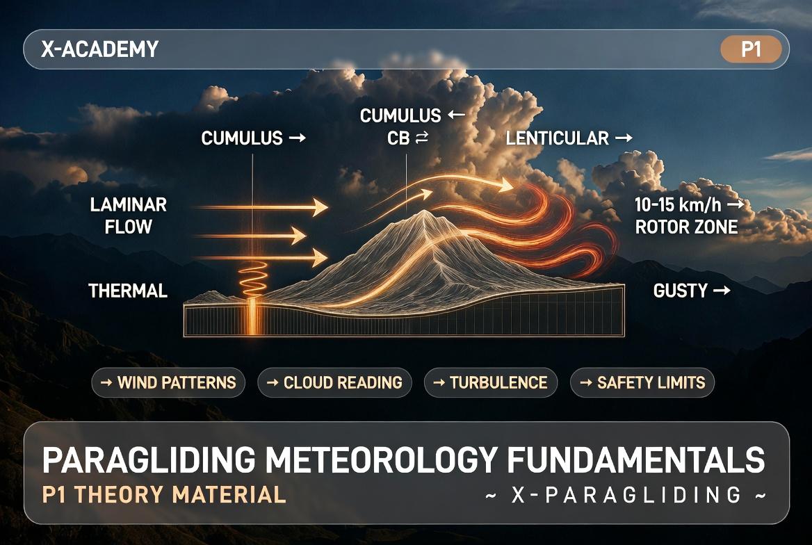
6. Reading Clouds: The Language of the Sky
Clouds are the best weather indicators. A beginner pilot must be able to predict current and future weather by looking at the sky.
- Cumulus: Beautiful, cotton-like clouds with a flat base and rounded top. This is a sign of good weather and thermals. Sun-warmed air rises and condenses. However, if these clouds grow vertically very fast, it's a sign of danger!
- Cumulonimbus (Thunderstorm cloud - Enemy #1): A giant, dark, rain and lightning cloud that often has an "anvil" base or a giant mushroom shape. It sucks in air like millions of vacuum cleaners. Even in its vicinity (10-20 km is not enough!), catastrophic turbulence, incredibly strong updrafts (where you can't bring the wing down), and severe gust fronts can form. Flying here is strictly prohibited - it is a deadly hazard!
- Lenticular Clouds (UFO-like clouds): Smooth, saucer-like clouds that form over or behind mountains during strong winds. They stand motionless in the sky, although the wind inside them moves very fast. This is a guaranteed sign of strong mountain waves and brutal rotor turbulence. If you see a lenticular cloud in the sky, novice pilots must not fly!
7. P1 Pilot Safety Minimums and Limits
Knowledge of meteorology theory must be applied in practice. Strict meteorological limits are set for P1 pilots:
- Wind Speed: Ideal wind for beginners is 10 to 15 km/h (headwind). Flying is not allowed if wind speed exceeds 18-20 km/h, or if rough "gusts" are observed (sudden, sharp changes in wind speed - e.g., from 10 to 25 km/h).
- Visibility and Precipitation: No fog or rain! A wing wet from rain becomes significantly heavier, loses its aerodynamic properties, drops in speed sharply, and easily enters a "Deep Stall". Flying in fog causes loss of orientation and increases the risk of terrain collision.
- Time: P1 pilots are recommended to fly in the morning (just after sunrise) or late evening when the atmosphere is calm, thermal activity is minimal, and the wind is stable. Midday "mad" hours should be given to resting and observing senior pilots.
- Assessment (Wind Dummies): Always observe nature - swaying trees, flying birds. If waves on the water create whitecaps, it means the wind is over 25 km/h and flying is dangerous.
Conclusion
A good pilot involves three things: wing control technique, common sense (mental state), and accurate weather assessment. Never rely solely on phone apps (Windy, Meteoblue) - they provide a general picture, but local micrometeorology must be assessed on site. Remember the golden rule of paragliding: "It's better to be on the ground wishing you were in the air, than in the air wishing you were on the ground!"