Meteo-analysis for an XC pilot is not just about gathering information—it is the foundation of safety. A correctly interpreted forecast tells you where and when flight is possible and, most importantly, when you should refrain from taking off.
Here is a structured and organized guide to meteo-analysis for professional XC pilots:
1. The Synoptic Situation: Seeing the "Big Picture"
Before moving to local thermals, you must understand the conditions in the upper layers of the atmosphere.
Pressure Systems: A High-Pressure (Anticyclone) system usually means stable, sunny weather, though excessive pressure can "suppress" thermals. A Low-Pressure (Cyclone) system is a precursor to instability and precipitation.
Frontal Systems: Keep an eye on approaching cold fronts. Ahead of a front, the wind always intensifies, and the air becomes turbulent.
Isobars: The density of isobars (lines of equal pressure) on a map directly indicates the strength of the pressure gradient wind. The closer the lines, the stronger the wind.
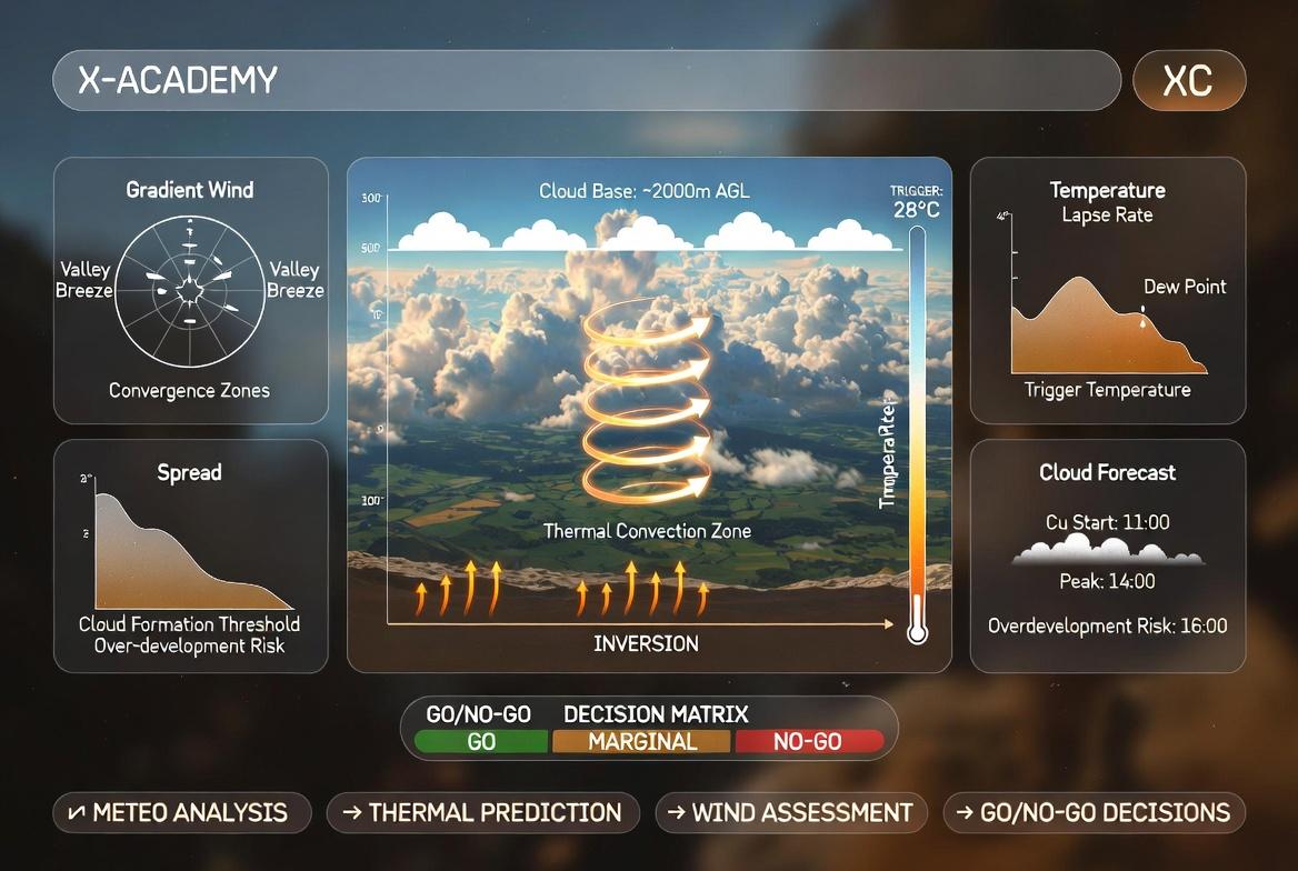
2. Aerology and the Skew-T Diagram: An "X-ray" of the Sky
This is an XC pilot's primary tool. A Skew-T (or Emagram) shows the state of the air according to altitude.
Lapse Rate (Temperature Gradient): If the temperature drops rapidly with altitude (0.6°C to 1°C per 100 meters), thermals will be strong and high-reaching.
Inversion: This is the "invisible ceiling"—a layer where the temperature increases instead of decreasing. An inversion stops the ascent of thermals. For XC, a "weak inversion" at high altitude is ideal.
Cloud Base: The point where the temperature and Dew Point lines converge. This determines at what altitude Cumulus (Cu) clouds will form.
3. Wind Profile and Turbulence
Wind at altitude often differs radically from surface wind.
Wind Gradient (Wind Increase): If wind speed increases sharply with altitude (e.g., 15 km/h at 1500m but 40 km/h at 2500m), it creates heavy turbulence and "breaks" thermals.
Wind Shear: An abrupt change in wind direction at altitude. This complicates route planning and makes "staying in the thermal" difficult.
Overdevelopment: If the atmosphere is too unstable, cumulus clouds can grow into Cumulonimbus (Cb)—thunderstorm clouds—which are strictly prohibited for flight.
4. Local and Relief Effects
An XC pilot must know how their specific flying location works.
Valley Wind: During the day, wind strengthens within valleys. You should know where the "Venturi effect" (wind acceleration in narrow gaps) occurs.
Trigger Points: Terrain features (rocky ridges, dark slopes) that heat up first and "release" thermals.
Shadowing: If cloud cover increases excessively, the ground will no longer heat up, and thermals will "die."
🔍 Recommended Tools:
Meteoblue / Windy: For visual maps and thermal forecasts.
XC Skies / RASP: Specialized aviation models for paraglider pilots.
Hovmuller Diagrams: For observing wind changes over time.